


The Role of Drones (UAV) in the Mining Industry
Although the integration of drone technology in the mining sector is relatively nascent, its potential benefits are substantial. As adoption rates rise, both individual companies and the industry at large stand to experience significant improvements in safety measures and cost reductions. Since 2016, major corporations with ample resources have been at the forefront of drone trials for mining, with 70% actively conducting experiments. In contrast, only 37% of smaller to mid-sized enterprises have ventured into the realm of drone technology for mining. Nevertheless, the embrace of drones within the mining industry is gaining momentum swiftly, and companies of varying sizes are swiftly realizing the myriad advantages associated with incorporating this technology.
1. Survey and Mapping
Geospatial data is the backbone of a mining firm. This data collection, and the processes involved in collecting the data, provides indispensable information to all the other mining disciplines. Within those disciplines, surveying and mapping is one of the largest operating expenses a firm has to manage on an ongoing basis. Historically, surveying and mining can be traced back to ancient times. The Romans were renowned engineers using many different survey methods, and they were ultimately responsible for the incredible Rio Tinto copper mines. In more modern times, the traditional means for providing the enormous streams of data needed to operate a mine from surveys and mapping still tend to be costly and labor intensive. Today, companies are using a variety of methods such as terrestrial site laser scanning with the global navigation satellite system (GNSS), manned airborne laser scanning, photogrammetry, and the use of unmanned aerial systems (UASs) with unmanned aerial vehicles (UAVs), or drones.
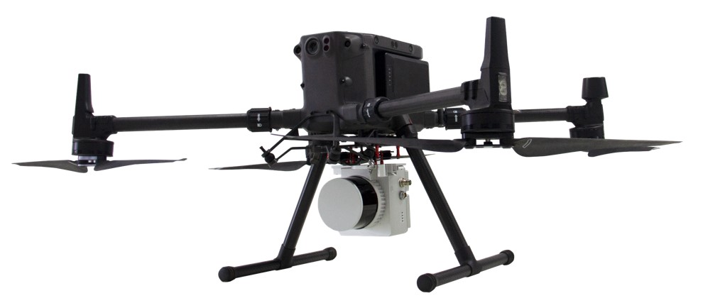
“A new disruptive technology in the broader geospatial industry that can bring benefits for the mining sector too is the combination of UAV and Lidar. This may have the potential to replace many existing options.” The advantage drones have over more traditional methods is more than just a cost savings for the firm. Drones can provide very high-resolution imagery, 2-D mapping, 3-D mapping using LiDAR, digital elevation, terrain modeling, and the ability to do these functions repeatedly. This lowers the time it takes to collect and process the data needed to operate the mine, all while lowering the overall operating expenses. One of the original drones used for surveying and mapping is the DJI Matrice 300 which comes with an integrated RTK system. It has an impressive flight time of 50 minutes depending on the payload and it can fly in very high winds compared to other drones in its class, up to 28 mph. This drone is used for rough terrain, and hard-to-reach areas.

2. Monitoring and Inspection
Monitoring and inspecting are vital to the success of any mining operation, especially when it comes to tailing dams. Tailing dams are embankment dams used to store waste after the ore has been extracted and separated. These dams can be potentially harmful to the environment, pose a risk to nearby communities, and can be a significant risk to those individuals tasked with monitoring and inspecting the earthen dams.
This is an area drones are particularly well suited for, and at a far lower cost. Drones can also do this while mitigating the risks involved in having the tasks performed manually. Drones allow site managers to see changes in these dams very quickly. This allows them to take immediate action when there are issues identified by the drone data, especially involving structural integrity concerns.
Using drones for monitoring and inspection is not exclusive to tailing dams. Drones are often utilized for underground mines as well, especially inspecting underground sites for stopes (underground caverns created after blasting a particular area). These areas need to be analyzed for stability, to determine the proper amount of backfill, and to identify areas that need additional support.
Until recently there were very few commercial drones available that had the capabilities to do this type of work, but the field is advancing very quickly. The Elios 3 by Flyability is one such drone. Equipped with an impressive LiDAR sensor with real-time 3D view of the drone’s trajectory and environment, a 4k camera and a Dual Thermal/Camera Sensor, ability to stream live in HD at speeds of 6.5m/s. The Elios 3 is built to be operated in confined spaces, comes with a carbon fiber cage minimizing damage should it crash, and can operate beyond visual line-of-sight.

Copyright: Elios
3. Safety
One of the amazing statements made about the Elios 3 is “the Elios 3 is built to keep humans safe while collecting data in areas that have been inaccessible in the past.” Regardless of the drone or UAS being used, this sentiment is a resounding reason for using drones in the mining industry.
On 30 September, a gold mine in Chegutu, 100km (62 miles) west of the capital Harare, Zimabawe collapsed with more than 30 people trapped. Drones have a clear use in search and rescue efforts. Following the devastation caused by Hurricane Katrina, the FAA in 2006 started allowing UAVs to fly in civilian airspace for search and rescue and disaster relief operations. Since then, the technology has dramatically improved, and continues to do so, making search and rescue a vital part of using drones for mining purposes.
“The drone is an extremely cost-efficient way for us to capture these photographs, whereas traditionally, we would have needed to get a professional photographer in a helicopter.” Using drones for search and rescue, where lives are in immediate danger, is not the only reason for using drones for safety purposes. Most drone usage for mining safety comes with improvements in normal day to day operations.
Drones allow you to examine areas of the mine or quarry where using traditional survey equipment is very difficult. This in turn eliminates hazards employees may typically face while climbing stockpiles, walking through dangerous zones, or navigating active sites. Drones in turn do all of this without disrupting the flow of operations and the need to move machinery. Each situation is uniquely different, and a multitude of drone types could be used for aerial search and rescue, but the one best suited for the job would be the Matrice 300 RTK drone.
4. Route Logistics and Planning (Exploration)
Route logistics, in the form of road optimization, and exploring new locations, are important aspects of operating a mine. Site managers need to inspect and monitor the state of the haulage roads frequently so that they can be maintained for better transportation of goods. This requires a lot of planning and exploration.
It has only been within the last few years drones have been able to break the technological hurdles needed to carry out these tasks efficiently. In the past this has involved many different methods such as fixed-wing plane images, satellite imagery, and geophysical and magnetic surveys. These types of surveys are traditionally very difficult, and costly. It often involved hauling heavy equipment around, walking with a ground-based magnetometer (which is very slow), or flying a demagnetized helicopter (which is very expensive).
Today, drones have completely changed how mining operations explore and create their infrastructure. Drones can now produce very high-resolution orthophotos and digital surface model (DSM) maps to support their mining exploration efforts. Drones with airborne magnetometers can conduct surveys five times faster and ten times cheaper than before. For this type of work, the payload capabilities of the drone are very important, and for this reason, the right equipment is vital.
Part of the UAS for route logistics and planning must include a drone mounted magnetometer. The MagDrone R3 is an ultra-portable magnetometer survey kit to be attached to any UAV / drone with a minimum payload of 1kg. Another option is the MagArrow UAV-Enabled Magnetometer which is engineered to simplify surveys that are difficult due to the various limitations of pilot-on-board surveys and ground surveys.
One of the most popular drones to be used for this type of work is the DJI Matrice 300 which has a working payload capacity of over 5kg. This platform was designed for professional aerial photography and industrial applications and is well suited for road optimization and exploration needs of the largest mining operations.
5. Stockpile Management
Stockpile management is typically how a mine estimates total volume of aggregate. Commonly this aggregate forms a cone-shaped pile on the ground and as this continually changes in volume it becomes more and more difficult to accurately measure the total volume accumulated. This can be done using GNSS Surveying, but these measurements are much easier to take from the air, and in the past manned aircraft were traditionally used to take these measurements.
Like many areas of operations in the mining industry, stockpile managers need to make use of an enormous amount of data. Traditionally, the data pertaining to stockpiles had to be collected during a semi-annual audit. This would then be used to calculate when materials would be available for sale. Drones using specialized software can now make these calculations, generate aerial terrain models, and identify measurements of stockpiles without the traditional expenses involved, and drones can be deployed more frequently. This means companies can carry out stockpile analysis as often as they would like.
This gives site managers a better representation of how much material is available, what can be extracted, and how much can be sold. This reduces write-offs and adds even more to the economic savings. Using drones for stockpile management can get very detailed, and is still a highly specialized field. It requires the right drone for the job, the proper software, and the right kind of experience and training. An example of a drone used for this application is the Vision Aerial Advanced Mapping Drone System (SVR), which is designed for high-resolution mapping and surveying, but there are many others that can be used as well.

ImageCredit: drone-works.uk
The Continued Use of Drones for Mining
As the use of drones continues to become less expensive, and the adaptation by other industries continues to increase, adaptation in the mining industry is sure to advance. Drone technology has already made a tremendous impact in other industries like residential construction, road and highway construction, and in the solar industry. Drones are poised to change the mining industry as we know it today by lowering operating costs and improving safety.
The Drone Life has extensive experience working with many complex industries, systems, and situations. The drone services we offer are unique to each client and designed specifically around your needs. We have an expert team of highly qualified licensed professionals ready to discuss your next project. Learn more about how we can help, schedule a free consultation with a drone expert today.
For mining operations seeking top-notch drone (UAV) mapping services, Geospatial Research LTD emerges as the trusted partner. The article underscores the company’s commitment to delivering high-quality data collection, expert analysis, and customized deliverables tailored to the unique needs of mining applications. From topographic maps to volumetric analysis and geological mapping, Geospatial Research LTD provides a comprehensive suite of services to optimize mining operations.
Author