


Exploring UAV LiDAR Technology: Unveiling the Future of Mapping
Geospatial Research Ltd, a leading LiDAR Survey Company in Nigeria aim to demystify the intricacies of UAV LiDAR, addressing commonly asked questions ranging from its functionality and alternatives to its benefits and optimal applications. Throughout this series, we’ll delve into key considerations for purchasing and utilizing UAV LiDAR systems.
Overview of UAV LiDAR Technology
LiDAR, or Light Detection and Ranging, stands as a remote sensing technology revolutionizing information acquisition without physical contact. Deploying lasers, LiDAR measures distances by emitting light waves and capturing the reflections. The emitted energy is termed a ‘pulse,’ while the reflected light constitutes the ‘return.’ Harnessing the speed of light and precise time measurements, LiDAR gauges distances in three dimensions.
Point Clouds and 3D Representation: LiDAR generates a collection of measurements called a point cloud, shaping a comprehensive 3D representation of the surveyed area or object. Beyond distance measurement, point clouds facilitate object extraction and classification, finding application in diverse fields from topographical mapping to cultural heritage projects, construction, and architecture.

UAV LiDAR: An Alternative for Comprehensive Mapping
UAV LiDAR, or Unmanned Aerial Vehicle LiDAR, emerges as a pivotal alternative for terrestrial and airborne LiDAR applications. Employing UAVs as carriers, LiDAR systems equipped with sensors, GNSS receivers, and IMUs capture precise and detailed data about the environment.
UAV LiDAR vs. Airborne LiDAR: While airborne LiDAR, often mounted on manned aircraft or helicopters, excels in large-scale topographical mapping, UAV LiDAR offers distinct advantages for smaller areas. With legal altitude limitations, drones provide enhanced safety and suitability for specific use cases.
UAV LiDAR vs. Terrestrial LiDAR: Compared to static terrestrial LiDAR on the earth’s surface, UAV LiDAR introduces flexibility and efficiency. The ability to overcome difficult terrain and hazardous locations, coupled with faster data collection, positions UAV LiDAR as a game-changer.
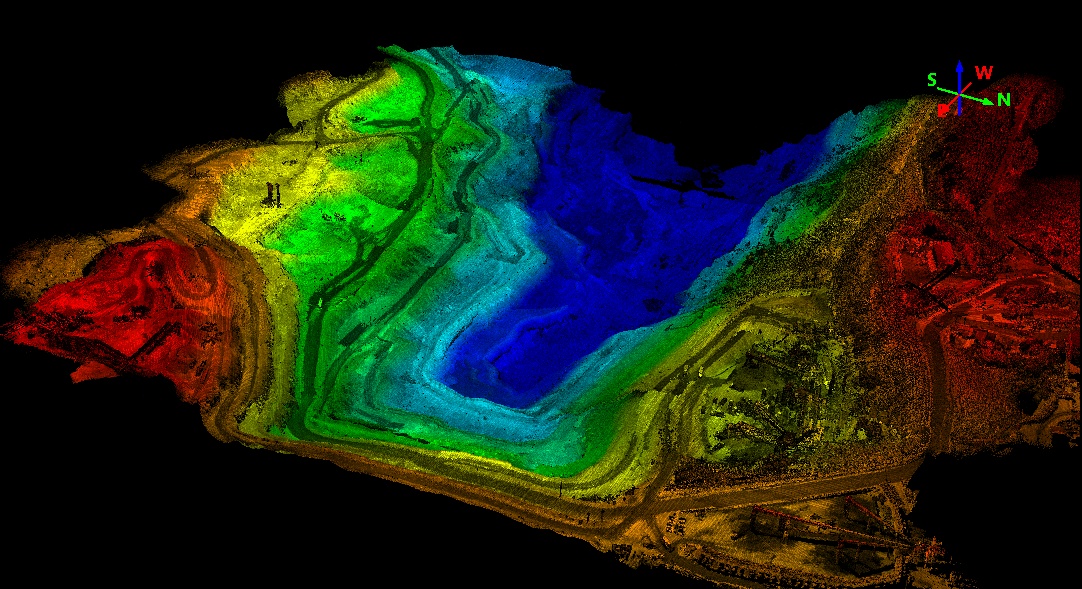
Best Use Cases for UAV LiDAR:
- Creating a DTM with UAV LiDAR:
- UAV LiDAR excels in penetrating vegetation to generate Digital Terrain Models (DTMs), differentiating itself from Digital Surface Models (DSMs). This capability proves invaluable in forestry management applications.
- Overcoming Difficult Terrain:
- UAV LiDAR proves instrumental in mapping challenging terrains, enhancing safety and efficiency in hazardous areas. Applications span open-pit mines, dam and water conveyance surveys, infrastructure assessment, landslide mapping, pipeline inspections, and archaeological site surveys.
Advantages of UAV LiDAR:
- Enhanced Safety:
- UAV LiDAR mitigates risks associated with hazardous environments, eliminating the need for human presence in dangerous areas. This ensures safer data collection without compromising accuracy.
- Cost-Effectiveness:
- UAV LiDAR offers a cost-effective alternative to airborne surveys, minimizing expenses associated with manned aircraft while delivering timely and accurate results.
- Fast Data Collection:
- UAV LiDAR significantly reduces data collection times compared to traditional methods. Rapid surveys, completed within hours, empower quicker decision-making.
- High-Resolution Data:
- Boasting high data resolution, UAV LiDAR systems capture detailed point data, ensuring accuracy and clarity in mapping applications.
This article provides a comprehensive introduction to UAV LiDAR technology, setting the stage for subsequent explorations into its nuances, applications, and evolving landscape. Stay tuned for more insights into the transformative realm of UAV LiDAR in our upcoming articles.
Reach out to Geospatial Research Limited, a leading innovator in geospatial technologies, with a primary focus on LiDAR and Drone Survey solutions. Established with a commitment to pushing the boundaries of precision mapping and data collection, our company has rapidly become a trusted partner for a wide range of industries seeking advanced geospatial insights.
At Geospatial Research Limited, our core expertise lies in the seamless integration of LiDAR and drone technologies. We specialize in providing comprehensive survey solutions that go beyond conventional mapping. Our team of dedicated professionals combines in-depth knowledge of geospatial sciences with cutting-edge technology to deliver accurate and actionable data.
Contact Geospatial Research LTD: info@geospatial.ng
Author